Ireland take 2: Wanderings in the south
- Dec 8, 2024
- 19 min read

A little bit of background📝
This post documents our week-long self-drive around the Republic of Ireland in April 2018. Our wanderings were part of a two-week trip to celebrate our 25th wedding anniversary, with our 17-year-old daughter, E, along for the ride.

We started with Easter in London then flew to Dublin. From there we hired a car and headed north, for two and a half days in Northern Ireland, staying in Belfast and driving up to the Giant's Causeway before exploring some of Ireland in the south. [Note: I'll refer to the Republic of Ireland as Ireland throughout this post, and the Island of Ireland refers to both Northern Ireland and the Republic of Ireland.]

Day 1: Started in Belfast, ended in peat boglands🚗🟫
We set out in the morning from Belfast, travelling until lunchtime to make it to Galway. This was a 325km trek south into Ireland and to the far west of the Island of Ireland.

We found a Subway for our lunch in a shopping centre built into the old city walls. How cool is that? I mean, the shopping centre, not the Subway. It's kind of the same, no matter where you go, right?

Galway is a city in County Galway, perched on the River Corrib between Lough Corrib and Galway Bay. Below are some shots from our post-lunch wanderings around the city. The arch you in the centre middle photo is part of the original city walls, built to protect the city's quays, constructed in 1584. Galway is quite a nice place, with its harbour, compact town centre, and pretty green spaces.

After leaving Galway we headed south towards our accommodation for the next two nights in the village of Spiddal. We had just started our journey along parts of the Wild Atlantic Way, a driving route that winds its way all along the west coast of the island of Ireland. The route in its entirety covers around 2500km of rugged landscapes and stunning beaches. As the below map shows, the Wild Atlantic Way starts in Muff in County Donegal in Northern Ireland and snakes its way south around the coastline all the way to Kinsale in County Cork in Ireland. I've circled the places we travelled to during our Ireland sojourn, and you can see them in relation to Belfast and Dublin. The parts of the Wild Atlantic Way that we experienced took us from Connemara to the Cliffs of Moher, to Dingle and further south onto the Ring of Kerry.

Heading west from Galway along the Wild Atlantic Way gave us the chance to experience an Irish beach. Nothing like the beaches in Australia! This was spring and E and I had long pants, jumpers, scarves, and coats on! Still, it was sunny at Salthill Beach and we managed to take some lovely photos. The one in the bottom left of the collage below is my favourite. The sparkly water against the stunning blue sky was a welcome sight, despite the cold temperatures.

Around 20km west of Galway is Spiddal, a village on the shores of Galway Bay and in the Connemara region, home to a beautiful national park. The peat boglands of Spiddal in the photos below were a surprise to us, and nothing like I'd imagined we'd see in Ireland. We got out of the car along the road to marvel at the landscape!

We'd booked into a 200-year-old thatched cottage near Spiddal for two nights. We met the cottage owner in the village and then followed her to the cottage as she told us we'd not find our way on our own. I get it, as the cottage is literally in the middle of nowhere!
Look at how adorable is it is, though, complete with a furry friend who jumped up on the kitchen window to greet us. Despite the bumpy road and isolated location - and no Wifi! - we loved the experience of staying in the cottage. It is so cute! The owner was adorable, too, leaving us freshly baked scones to enjoy, and bacon and eggs in the fridge.

Day 2: An abbey and a diamond hill in beautiful Connemara⛪💎
Around 80km west of Spiddal is Kylemore Abbey, sitting just on the edge of the Connemara National Park. The park spans some 2000 hectares of County Galway, from Diamond Hill south to Clifdon, on the western chunk of the country. The park has been open to the public since 1980. Kylemore Abbey was our first stop on Day 2 as we explored the Connemara region and the national park. What a beautiful setting!

Kylemore was built as a castle in 1868 by a wealthy businessman, Mitchell Henry, who was a key figure in Irish politics and social reform. Mitchell Henry built the castle for his beloved wife, Margaret, and the family lived there for 35 years. Since the 1920s, Kylemore has been home to an order of Belgian Benedictine nuns that was founded in 1598. The nuns came to Ireland as refugees after WW1 after their abbey was bombed in Ypres. From 1923 right up until 2010, the abbey was a boarding and day school for Irish and international female students. Here are a couple of shots from inside the abbey.

The grounds of the estate are the most impressive, I think. There's a large walled Victorian garden. We spent ages wandering around. Even though the abbey is a premiere tourist attraction in Ireland, it wasn't very busy when we were there. It was so peaceful strolling around the estate.

There's a neo-gothic church on the grounds, just a few minutes' walk from the abbey. Mitchell Henry built the 14th-century-style church again as a testament to his wife, Margaret, who sadly died in 1874 after contracting dysentery on a trip to Egypt. Margaret was said to have been a beautiful person and a mother of nine children. Margaret and Mitchell are both interred in the mausoleum that sits in woodlands near the church.

Here are some more shots of us exploring the estate. It really is beautiful as you drive up to it, with the abbey positioned on the northern shore of Lough Pollacappul at the base of the Druchruach Mountain.

I bought these beautiful prints at the gift shop at Kylemore Abbey. They really spoke to me as representing Ireland and I love that I have them as constant reminders of our experience.

After leaving Kylemore we drove the short distance to Diamond Hill, an isolated peak in the northwest corner of the Twelve Bens mountain range in Connemara National Park, close to the abbey and the village of Letterfrack in County Galway. The peak reaches 442 metres. The round-trip hike to the peak takes around 2.5 hours and is 7km in total, starting and finishing at the visitor centre. There's some steep climbing in places along a stone path trail and there's a wooden boardwalk on the flatter bits. The mountain was closed in 2002 due to erosion but was opened again in 2005 after completion of the €1.4 million boardwalk and trails.
The boardwalk is in the bottom middle shot of the photos below. It was foggy for much of the hike, but it was still a spectacular climb. It's really only the last quarter or so of the trek that's without a proper path and is noticeably steeper than the rest. As a person with terrible balance due to a hearing impairment, I was super proud of myself for making it to the top, even if I needed W's steady hand to help with some of the tricky bits. The bottom left hand shot gives you an idea of the final climb to the top of the peak.

Below are some shots of the views from the top and of the peak from below. Foggy at times, as I mentioned above, but still beautiful. On a clear day you can see the abbey and the Atlantic, apparently. Again, this was not a landscape I was expecting from Ireland, with its peat bogs, heaths, rocky hills, and interlocking lakes. There's a rugged charm to the landscape in this part of the country.

After finding a spot to eat a late picnic lunch, we spent the remainder of the afternoon exploring the Connemara region. The main shot in the below collection is my favourite that we took of the area.

We picked the Wild Atlantic Way back up on our journey home to the cottage in Spiddal. My photos say it all - just beautiful, in a savage kind of way...

This map gives a bit of an idea where we were poking around on the first few days in Ireland. The abbey and Diamond Hill are marked on the top map. We stayed in Spiddal and visited the abbey and did the Diamond Hill hike in the one day, covering a good portion of the Connemara region.

Day 3: More wilds of Ireland and some magnificent cliffs💖
Day 3 saw us head south from Spiddal along the Wild Atlantic Way, ending our day in Killarney. Around 50km south of Spiddal, past Galway, is Kinvara. There is a small village at the head of the bay, an inlet in the southeastern corner of Galway Bay. The castle that can be seen in the below photo is Dunguaire, a 16th-century towerhouse of the O'Hynes clan. It's a beautiful shot of the castle that I captured as well.

The Cliffs of Moher sit a further 60 km south and that was where we were headed next. On our way from Spiddal that morning we were treated to more of the rugged scenery along the Wild Atlantic Way. It sure is wild!

The Cliffs of Moher sit on the southwestern edge of the Burren region in County Clare. They span around 14 kilometres of sea cliffs and rise to around 120 metres above the Atlantic Ocean at the most southerly point, and 214 metres at the northern end. Even though is was a cold and slightly cloudy day, we were able to enjoy the full majesty of the cliffs.

The main platform affords fabulous views south to Hag's Head. It did make me a little nervous being so close to the edge. There's a barrier but also plenty of bits with nothing between you and a sheer drop below. The scenery is dramatic as it without the added element of danger!

Our final block of driving for the day was the 190km from the Cliffs to Killarney in County Kerry. What a different landscape to Connemara and the Wild Atlantic Way! This was what I was expecting from Ireland - lush green landscapes and rolling hills. Killarney sits in County Kerry, part of the northeastern shore of Lough Leane. The town dates back to AD 640!

We didn't explore the town itself, as we stayed on its outskirts at the fancy-sounding Killarney Country Club Irish Resorts, around 12km northeast of the town. It cost less than $400AUD for three nights, booked through Airbnb, so definitely value for money. What a cute place! The views out of the countryside are stunning, as the below collection shows. I've marked the red door entry to our cottage. I loved staying here!

Day 4: The Ring of Kerry⭕
The fourth day of our Ireland wanderings were spent on the Ring of Kerry. The Ring is a 180km circular route around the Iveragh Peninsula in County Kerry. The below map shows the route and the little chunk of the bottom of the island of Ireland that it occupies. There are loads of things to see on the Ring of Kerry. The map below plots the places we chose to explore on our day out, charting our journey from Killarney west after visiting Ross Castle and the Gap of Dunloe, down the Wild Atlantic Way and across to Staigue Fort before heading back up to Killarney National Park.

Our first stop was Ross Castle, only 3km from Killarney. The castle was built in the late 15th century by the local ruling Ross clan, in the style of an Irish Chieftain stronghold. The castle is surrounded by a defensive wall and towers. We arrived at the castle too early for opening time so we couldn't see inside but we still had a lovely time wandering around the exterior, all accessible without paying the entrance fee. Here we are having a poke around what's left of the castle.

Ross Castle sits on the edge of Lough Leane in Killarney National Park. The morning fog added an eerie atmosphere to our experience, especially since there was no one else there besides us. I can imagine it's beautiful on a nice day. Boat trips are available during the summer months.

Next on our Ring of Kerry itinerary was the Gap of Dunloe, 15 km around the lough from Ross Castle. Here's a picture of the landscape around the Gap. It was kind of spooky, actually, with the fog, the freezing cold temperatures, and the absence of people. To be honest, this is not the landscape I was expecting of Ireland. I thought it would be all lush, green valleys. There's a beauty in the stark landscapes, though, especially in the cold weather. [This is spring??!!]

The Gap is actually a narrow mountain pass running north to south that separates MacGillycuddy's Reeks mountain range in the west from the Purple Mountain range in the east. The river running through the Gap is the Loe, an anglicisation of the Irish word Loich, the Irish chieftain who lived there in ancient times. The Gap was formed 25 000 years ago during the last ice age where a glacial breach broke through the head of the gap in the valley. We stopped at the famous Kate Kearney's Cottage for a hot chocolate before tackling the narrow and winding public road.
It's a little hard to tell with the fog, but here's the Gap of Dunloe. It may not look much in my photos, but it was kind of cool to see, knowing its geological significance. The boulders in the area were formed millions of years ago when the glaciers cut a swathe through the valley.

We travelled another 30km towards the coast to our next stops at Glenbeigh and then at Rossbeigh beach. We didn't go into the village at Glenbeigh but instead explored the hills atop the village that gave us stunning views of the bay.

Just a reminder that we're on the Wild Atlantic Way here, so that it explains why it's kind of wild! Below is my collection of shots from Rossbeigh beach. There is sand in there somewhere, although I am not sure of the beach's descriptions as a "sandspit with beaches either side". There are sand dunes to explore and the beach is also an important flora and fauna habitat. It was a super cold day so we weren't motivated to go for a wander but it was just as nice to take in the peaceful vibe.

The best part was taking a wander onto the pebbled part of the beach. Just look at the beautiful multi-coloured pebbles, smooth and interestingly-shaped. The beach is nothing like we have where we live in Australia!

Driving a further 30km south, we stumbled across Ballycarbery Castle. The castle sits atop a grassy hill, the present ruins on which were thought to have been constructed in the late 16th century. The castle was once surrounded by a high wall, a little of which still remains, with the arrow slits visible. It used to be possible to walk around the castle grounds and climb amongst the ruins. Since 2017, the castle has been off limits to the public by decree of the owner, to prevent injuries and the potential for legal issues. My photos were taken from the parking area around 100 metres from the castle, as close as the public can get these days. But how cool are these shots?

Picnic lunches while on holidays are totally our jam, partly because we love poking around in foreign supermarkets. We'd been making sandwiches and eating fresh fruit and scones throughout our Island of Ireland wanderings, although it was often hard to find somewhere to picnic. The below photos are of us at two different locations attempting picnic lunches in the freezing cold weather. The middle shot was taken on our Ring of Kerry wanderings and the other two after we'd visited the Cliffs of Moher. I remember it being so cold and windy on our Ring of Kerry wanderings that we could barely sit at the picnic table and eat. We must have looked mad to the people out walking their dogs who spotted us!

After Ballycarbery Castle we travelled 45km down to the bottom of the Ring of Kerry and started to head back up again. Here are some shots of the scenery, including glimpses of the Wild Atlantic Way. Again, a stunning but rather desolate beauty to the place.

We braved the cold weather to have a poke around Staigue Stone Fort, a ruined stone ringfort thought to have been built during the late Iron Age - so somewhere between AD 300 and 400 - as a defensive stronghold for a local lord or king. We were the only people there, adding a few euros to the honesty box at the fort's entrance.
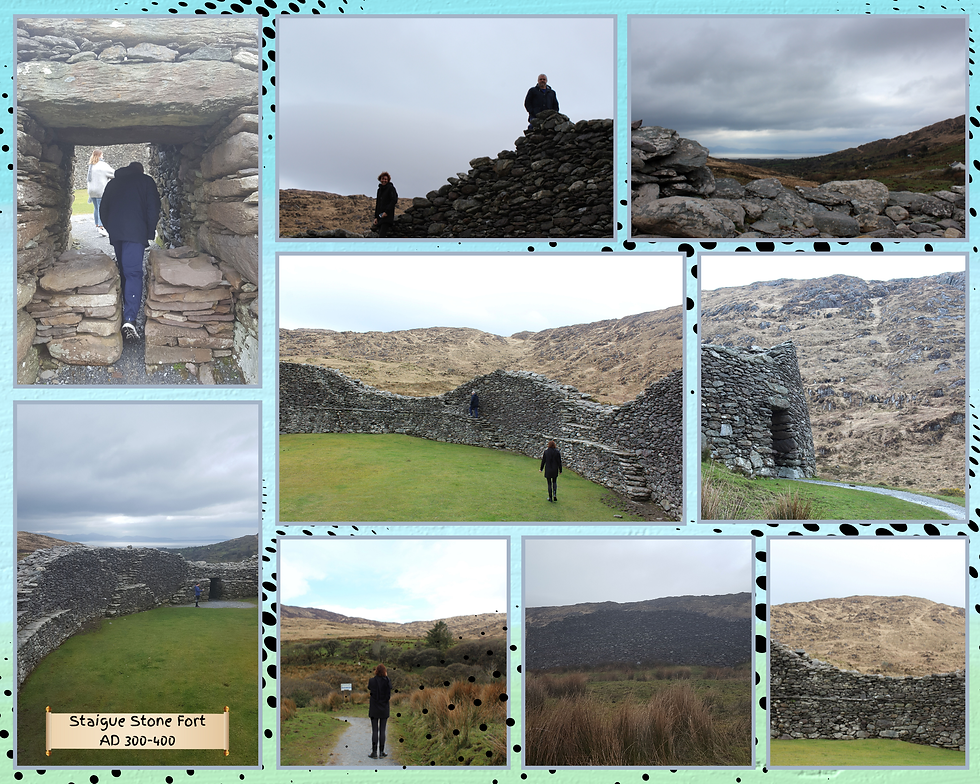
The fort's walls are up to 5.5 metres high in places and 4 metres thick. I've read that the fort represents a significant feat of engineering as it was built without mortar using undressed stones of local sandstone. The vertical joints that can be seen in the walls show the gaps that were left during construction to allow access, but later filled in.
Our final bit of driving saw us head 58km back up to Killarney National Park where we had started our journey around the Ring of Kerry. We stopped a few times for photos of the stunning landscape.

Once back in Killarney National Park, the landscapes become lush and green again. We stopped at Torc Waterfall for our penultimate wandering on the Ring of Kerry. The waterfall is 20 metres high and is formed by the Owengariff River. Its Irish name, Easach Toirc, means 'cascade of the wild boar'. The waterfall sits on a geological fault - the Muckross to Millstreet Fault line - and the base of Torc Mountain is thought to be 400 million years old. The waterfall is 7km from Killarney and only a 200 metre walk from the car park by way of a stone path of around 100 steps.

What struck us the most was all the moss on the trees. The moss lends an otherworld vibe to the landscape, creating a velvet-like covering that adds to the ancient feel of the place. It must be so consistently wet and cold for that amount of moss to grow!

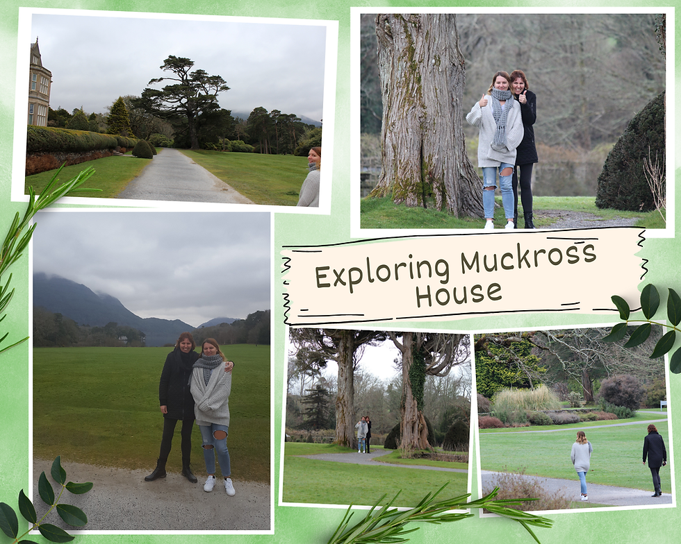
A further 2.5km along the road back to Killarney is Muckross House, our last stop for the day. The house and grounds sit on the tiny Muckross Peninsula between the lake of the same name and Lough Leane, two of the lakes near Killarney.

The Victorian mansion was built in Tudor style, originally constructed for Henry Arthur Herbert and his wife, Mary Balfour Herbert, in 1839. The mansion was extended and remodelled for Queen Victoria's visit in 1861. The cost of these works took its toll on the Herbert family and they were forced to sell the estate to the Guinness family. The estate was later sold to a mining tycoon from California and was finally donated to the Republic of Ireland in the 1930s, becoming the first national park in the country and the basis of the current Killarney National Park.
Tickets at the time of writing to see inside Muckross House cost only €9. It had been a long day for us and we didn't have the energy or desire to see inside, but we had a lovely time wandering around the magnificent and extensive gardens, even if it was freezing cold.
It was our actual 25th wedding anniversary this day, and we decided to take a drive out to Dingle Peninsula for dinner, even if we were bone tired. The peninsula is the northernmost of the major peninsulas in County Kerry and the westernmost point in Ireland. It exists because of the band of sandstone rocks that forms the Slieve Mish mountain range at the neck of the peninsula and two other mountain ranges in the area.
Dingle Peninsula is stunningly beautiful but also important geologically as it is home to numerous prehistoric and early medieval remains. We were fortunate to be there at the as dusk approached. Look at how pretty it is!

And finally, here is our anniversary dinner in Dingle. Fish and chips of course!

Day 5: Dublin bound☘️
That was it for our Kerry wanderings and on Day 5, we drove back up to Dublin. The route took us diagonally across Ireland, via Limerick, travelling some 300km. We pretty much breezed through Limerick as it was a bit depressing, although the dreary weather didn't help matters.
We stayed in a Staycity Aparthotel in St Augustine Street. The place was in a great central location, with undercover parking. Our apartment was more like a small flat so we were super comfortable there. I don't have any photos of the apartment and when I looked it up to write this post I discovered it is permanently closed. There are still six Staycity aparthotels in Dublin, though.

Below are some random shots from our two-day wanderings in Dublin. The weather was pretty rubbish - cold, grey, and showery - but I can see there is a certain charm to the city, with the River Liffey cutting through the middle, lots of history, and the trendy areas filled with cafes and bars. We'd arrived in Dublin by lunchtime and found Market Bar, a trendy place to eat [top left hand shot below] in George's Street Arcade. There's quite a buzzy vibe to the centre of the city.

After lunch we found the pretty St Stephen's Green. The park dates back to the late 19th century and spans 9 hectares, the largest park in Dublin's main Georgian square gardens. It sits adjacent to the famous Grafton Street, the main shopping street in Dublin. There's also a link to the 1916 Easter Rising, when a group of rebels took up position on the Green.

Trinity College is only 2km from the park. As a university person, I was thrilled to wander around the campus. Trinity is one of the most prestigious universities in the world, with notable alumni including Oscar Wilde, Jonathan Swift, Samuel Beckett, and Bram Stoker. It was founded in 1592 by Queen Elizabeth I who issued a royal charter to build the first university in Ireland modelled after the collegiate universities of Oxford and Cambridge. Its founding in 1592 puts it in the group of seven ancient universities in Great Britain and Ireland and in the company of the oldest continuing universities in the world. The ancient universities include Oxford, Cambridge, St Andrews, Glasgow, Aberdeen, and Edinburgh, and of course Trinity.

We could have bought tickets to see the Book of Kells, the most famous book in Trinity's library, but we were happy just to wander around the beautiful grounds. I've been to several historic universities around the world and I feel privileged just to set foot on the hallowed grounds.
Day 6: More Dublin wanderings and a visit to an historic gaol⛓️💥
On our second day in Dublin we bought tickets to visit Kilmainham Gaol Museum, opened in 1796 as Dublin's new County Gaol. The goal housed common criminals and political prisoners involved in Ireland's fight for independence, including leaders of the 1916 Easter Rising, some of whom were executed by firing squad in Stonebreakers' Yard. The goal was closed in 1924 and later preserved as a national monument in the 1960s.

Entry to the gaol costs €8 and is still only available via a guided tour that must be pre-booked here. I recall that the tour we did was interesting and informative. We learnt that some prisoners had been sent to Australia during the era of convict transports. The poor conditions in which men, women and children were kept are still apparent in the museum.
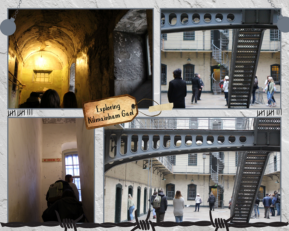
The gaol has been used as a film location since the mid 1960s, including In the name of the father (1993) and Michael Collins (1996), and more recently the second Paddington film (2017). It might seem like an odd thing to do on a holiday, but as a history nerd, the tour was totally my thing. It was quite eerie walking around the prison, especially since it was such a bleak day.
We spent the rest of our day wandering around Dublin, making a pit stop at the Irish Museum of Modern Art café, housed in the Royal Kilmainham Hospital, a building constructed in 1684.

Here's a collection of shots taken from our Dublin wanderings. It looks bleak - and I suppose it is - but there's so much history to the formation of Ireland, and the city has its own kind of charm.

I can't help but love a city with a river as its central feature. There are lots of bridges that cross the Liffey, just as they do in London, but they don't have the same majesty as the Thames bridges. The Liffey is actually rather an impressive river, though, with a catchment area of 1256km and dozens of smaller rivers and more than 100 named streams. There are dams for three hydroelectric power stations along the river and 60% of the flow is used for drinking water and to supply industry.
I'm sure the weather had an effect on our impressions - grey skies and clouds for the entirety of our visit. My photos tell that story!

Day 7: Homeward bound✈️
One thing I have learnt from my travels is that it is better to arrange homeward flights for first thing in the morning or super late at night when you live at the bottom of the world. Early mornings are best, so you can wake up and just get on with it. Late evenings can work, too, as you have the whole day to make final wanderings and don't feel so pressured to keep an eye on the time. This time we were due to fly home in the early evening, from Dublin to Abu Dhabi to Sydney and then finally home to Brisbane. Our flight from Dublin wasn't until 7pm but we woke up on that last day feeling unsettled. We didn't seem to know what to do to make the most of our final day in Ireland.
We drove out to Howth in the morning, as we'd been told it was a pretty place to visit. Howth is apparently an affluent place, a peninsular village and outer suburb of Dublin. The area had been settled since prehistoric times and features in Irish mythology. There is a hike and there are a number of historic places to visit in Howth, but by the time we got there on our last day, we'd run out of steam.

I remember we drove around for ages trying to find somewhere for lunch and debated how to fill in our afternoon, but in the end we just went to the airport early. Sometimes the pace and fullness of our wanderings catches up with us!


Despite the pretty ordinary weather, we absolutely loved Ireland. I recommend exploring the country with a car as there's a lot to cover and it's much easier to get around if travelling independently with a car. It is possible to set up camp in Dublin and do day tours from there, but that would limit the experience, I think. There's so much choice as to how to spend the time as there are lots of museums, castles, churches and other historic monuments to visit. We preferred to mostly stick with exploring the natural spaces, and immerse ourselves in the diversity of landscapes and majestic coastlines. While we did see a fair chunk of the country, there are still places we didn't see, mostly around Cork and Waterford. I'd also like to go back in better weather, so my advice is to plan a trip for summer. Oh, and the Wi-Fi was super efficient, often working for us when we were parked in the car out front of a building! [This we noticed as Australia has rubbish Internet.]


While the trip was our chance to explore Ireland, it was also a full circle moment for us. We got married in 1993 and couldn't afford a honeymoon. We saved like crazy for over a year and embarked on a wonderful adventure in 1996, visiting England, Scotland and Wales, as well as Los Angeles for a stopover and a bus tour of Europe. We weren't able to make it to Ireland and Northern Ireland, so this trip was especially meaningful to both of us. We have come so far in that time, too!

Ireland is a beautiful place! I wasn't expecting such a diversity of landscapes, from lush and green to raw and desolate.
There are loads of "tourist things" we could have done, but we were happy in the natural landscapes, despite the weather. I feel incredibly at peace in pretty places.
The weather is one of my most vivid impressions. It was so cold and bleak and I wish we'd had more sunshine to give us a different impression of the country.
If you want to read more about the other parts of our trip, check out my post on our Easter in London and our day in Belfast and drive up to the Giant's Causeway.


Comments